Showing posts with label White River. Show all posts

Oct 9, 2012

The Odyssey Has Begun...

Passing the ruins of
Monte Ne


The Indians living along its banks called it Unica, which means "white,"  referring to how clear it was.   French colonists later memorialized it as the Riviere Blanche.  Today we call it the White River, the queen of the Ozarks and the king of Arkansas Delta.

Ballad Hunter: Listening To the White River is a river journey by author-photographer, Chris Engholm, who is canoeing the 720-mile length of the White River  from its headwaters in the Ozark Mountains to its mouth where it marries the Mississippi River.

Along his river journey, Engholm is meeting with families who have lived in harmony with the river, in many cases since before the Civil War. He is encountering remnants of the old 'cracker culture' in the hills and hollows of the Ozark Plateau and vestiges of plantation life in the Delta, meeting itinerant  musicians, curmudgeonly fisherman, cantankerous environmentalists, and even "rewilders"---young people going back to the land, getting off the grid and settling along the river.

A swimming hole near the headwaters of the
West Fork of the White River


A Liquid Legend

Few Americans outside Arkansas have ever heard of the mighty White River, minus a contingent of savvy fly fishers who know its Bull Shoals tailwater as America's trout Mecca. When I first met the White it was love at first cast.  This was partly because I'd been imagining a river like it for most of my life.  This site tells the story of my personal journey to comprehend  this mighty waterway, its natural rhythms, flora and fauna, and how man has lived in tandem with it for centuries.



The hook-shaped White River and the places
Chris Engholm has visited and floated so far. 
         

Chris Engholm can be reached at
chris@chrisengholm.com


Feb 13, 2012

Look Who's In the Canoe ! (On Sunday, Mar 4th--9am)

On Sunday at 9am, we'll be at Monte Ne put-in to paddle BalladHunter along the ruins.  More importantly, I will have local historian Allyn Lord (Director of the The Shiloh Museum of Ozark History) in the bow  answering questions about Coin Harvey, the history of the old resort, and recent efforts to preserve it.  Come down and paddle around with us.  The weather is supposed to be fine.  


Incidentally, Allyn is a partner with me on White River Memoirs, an oral history project described at http://www.whiterivermemoirs.blogspot.com.


Update: The "ruins float" was most satisfying and informative. It was freezing and socked in when we left the shore but by the time I got the camera running, the sky cleared and the sun struck the old Monte Ne Tower like a cymbal.  Allyn proved once again to be the 'professor of Coin Harvey,' and a great on-camera presence even with a nasty spider bite on her forehead...which we adroitly covered with a ski cap.  I will get some video clips up asap. 

Aug 24, 2011

Day Trip: Lake Sequoyaw and Upper White

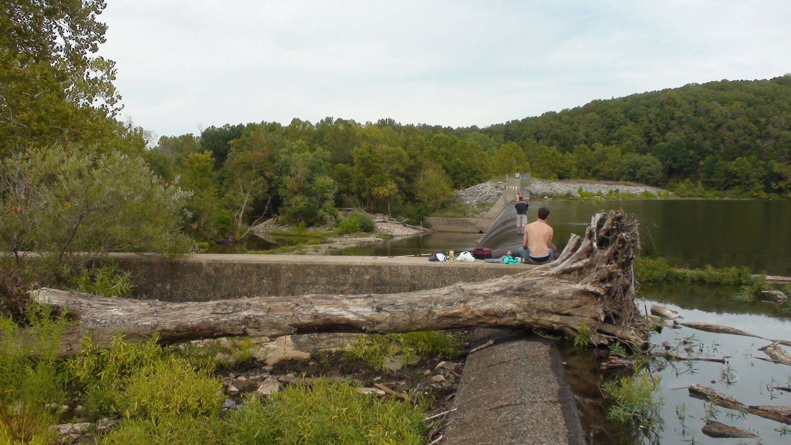
If you get a free afternoon this fall, head out Hwy 16 east of Fayetteville and check out Lake Sequoyaw (that might not be the exact spelling).  It's the first impoundment on the White River and offers great scenics and sometimes, great fishing for perch, bass, and crappie.  I visited the dam at its north end to photograph the 'ripa' there and get the lo-down on the fishing from some locals.


The footpath to the dam area at the north end of the
lake leaves from the parking area.

Weapon of choice in the weeds and
logs: a weedless rubber frog.

Gilbert, Larry, and friends traverse the dam hunting bass.

Great bass and perch holds in the grass at the north end of
the lake, this shot taken from the spillway. 

The spillway appears slimy and treacherous to walk upon
 it's actually a breeze to walk out the 100 yards to the dam. 


The dam and the White River continuing below.  The pond
was occupied by a 40-pound carp, a paddlefish,
and a small black gar. 

Riparian biome extends from the
spillway into the tree line. 

A log across the spillway with a water moccasin hiding
beneath it.  Luckily, Gilbert there warned me about it
before I sat down. 

On the Trail of Schoolcraft: Theodosia and Beyond

The explorer Schoolcraft passed this way in the 1800s.  I just finished reading his historic “journal” where he describes his canoe voyage down the White to Batesville, then called Poke Bayou.  He was a scientist, traveler and a pretty decent naturalist and geologist for his time.  His description of Calico Rock reads like nature writing at its best; in fact, Quincy Wolf, Sr quoted the passage in his famous Ozark memoir, Life in the Leatherwoods.  I must say, however, that the effect is a little disturbing because the White River isn’t as clear and pristine as Schoolcraft describes it, nor quite so brimming with aquatic life.  It’s beautiful in sections, to be sure, but reading a personal journal of how it was -- before dams, chemical pollutants and channeling – gives one pause.  What would it be like to see it again through Schoolcraft’s eyes?  And what ‘is’ the state of the White in regards to its ecological health?  I’m sure it’s better than most large American rivers, but is it as good as it can and should be?

White River and Mall Pond in Branson, MO
The bridge over Bull Shoals Lake
in Theodosia, MO.  A few miles further
is Pontiac, a settlement that Schoolcraft
visited.

Goldmine In Huntsville at the Madison County Historical Society


On a recent journey to the “White River Trout Capitol” town of Cotter, driving on Highway 412, we decided to check in with the public library in Huntsville, the seat of Madison Country to see what historical gems they might have in the stacks. The friendly librarian there clued me into the active genealogical society in town, which we aimed to visit.  There I met Duane, who tends the historical society, and he showed me around the collection. The society’s growing library of volumes documenting the families, stories, and cemeteries of the county made a deep impression; I hadn’t seen this sort of folk archeology being done anywhere in southern California, nor in Central America where my family had recently been living. One volume recently published we like is titled, “Pettigrew: Hardwood Capital of the World.”  Pettigrew is situated along the White River very close to its headwaters southeast of Fayetteville some twenty or thirty miles. 

Duane kindly provided us some key contacts for future interviews and showed us his method for scanning family photos.  Tragic-comically, his recent efforts in backing up the collection left something to be desired.  The moral was: if you erase the files on your desktop because you have a ‘backup’ on an external hard drive, then the hard drive is no longer a ‘backup.’ At any rate, a big thanks to Duane at the Madison County Historical Society in Huntsville!

Daytrips To the Lower (and Upper) White River

A couple of interesting day trips to the White River you might consider for a weekend when the trees change...

1.  Last week I drove out to Des Arc to see the Lower White River Museum.  The museum is small  but a great introduction to the river, and the town has a lot of history that you can learn about at the local library. The river is huge here and comes under an impressive steel bridge that's a major photo opp.  Upstream you can find easy fishing lakes and other river towns like Georgetown, which was nearly inundated by flood waters last May.  The Red River joins the White in this area and is a clear-water fishing stream this time of year--just a purdy as a spotted puppy.

2.  Yesterday, after dropping my son at his girlfriend's in Huntsville, I drove along Hwy 74 from there down to Elkins.  It was raining at first but cleared as the sun set by the time I went over the White River on a bridge into Elkins.  Wow, the light set the slow-moving waters and lush banks alflame -- I've never seen a more spectacular river view.  Photographers beware, however, the bridge has no sidewalk and the drivers here are cityfolk heading to Fayetteville late for appointments.  One false step and you'll end up like the deer carcass I saw at the foot of a piling under the bridge!  Take a good map with you and try the blue highways the head north from 74 and pass through the rolling farm estates along Richland Creek and end up in either Goshen or Lake Sequoia just east of Fayetteville.  You'll find yourself house hunting for sure.

Aug 23, 2011

The Upper White: War Eagle Creek

 Over the weekend we ventured up War Eagle Creek, a tributary of the White River that originates near Huntsville.  Here are some views.  I'll provide more information about this watershed soon.


I reached a bridge over a river after dark
thinking I was still near Eagle Creek.  Looking at
the topo map later, I found I had found an
incredible spooky stretch of the King's River.
Eagle Creek and cumulus after it
passes under Hwy 412.